AP23489830 – Development of integrated Remote Sensing and machine learning technologies for landslide monitoring and assessment
Objective of the project – The project aims to develop and implement integrated technologies, combining Remote sensing (RS) data and machine learning, for enhanced monitoring and assessment of landslide risks.
Relevance: The project aims to analyze landslide formation processes associated with deformable rock in areas of heightened landslide risk in the city of Almaty and surrounding regions. In these areas, steep slopes, construction activities, and seismic activity exacerbate the landslide risk. The study utilizes remote sensing data and GIS technologies to monitor and assess landslide hazards. The primary objective of the project is to develop detailed landslide hazard maps for emergency response services and local authorities. The project aims to improve methods for predicting and preventing landslides using modern technologies, including machine learning and mathematical modeling.
Scientific supervisor: Ph.D., Director, Orynbasarova Elmira
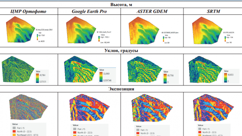
Expected and achieved results: Results were obtained for landslide classification, analysis of digital elevation models (DEMs), and post-processing of second-order GNSS measurements. Based on aerial photographs captured using a UAV, a digital elevation model (DEM) with a pixel resolution of 10 cm was created; morphometric parameters (slope, aspect, curvature) were calculated, and slopes were classified according to their hazard level. Potentially unstable sections and priority areas for further monitoring were identified. A geospatial database was created, and deformations were classified by type and origin. A second cycle of GNSS measurements was conducted; displacements were determined and zones of active deformation were identified, characterized by subsidence of up to 8–9 cm and horizontal displacements of up to 3–4 cm. The analysis revealed the influence of soil water saturation and geological conditions on slope dynamics. The effectiveness of integrating data from unmanned aerial vehicles (UAVs), geographic information systems (GIS), and geodetic monitoring was confirmed. A data archive was created and systematized, including SRTM data, satellite imagery, as well as geological and meteorological data. An analysis of landslide types and their formation factors was conducted. Visual surveys and preliminary GNSS measurements were carried out, and areas of the highest landslide activity were identified. A geospatial database was created in ArcGIS Pro (in gdb format), integrating all collected data and spatial analysis tools..
List of publications with links to them
Илиуф Ф.А., Садыкова Т.С., Камза А.Т., Бейсенбаева С.Ж. Сравнение цифровых моделей рельефа на примере склона международного комплекса лыжных трамплинов «Сункар» // Горный журнал Казахстана. – 2025. – DOI: https://doi.org/10.48498/minmag.2025.242.6.006