Water in GIS format: the Atlas of hydrogeological maps of the Republic of Kazakhstan
Satbayev University is participating in the creation of one of the key scientific and infrastructural projects in the field of natural resource management — the "Atlas of Hydrogeological Maps of the Republic of Kazakhstan," implemented using modern geoinformation technologies. The project is aimed at the systematization and comprehensive analysis of data on the country's groundwater, the formation of a unified digital model of the underground hydrosphere, and the development of a scientific foundation for sustainable water use. Its implementation aligns with the UN Sustainable Development Goals, including SDG 6 (Clean Water and Sanitation), SDG 9 (Industry, Innovation and Infrastructure), and SDG 13 (Climate Action).
The Atlas has been developed as an integrated geoinformation system combining multi-layered maps of various content and scale. At its core lies the synthesis of many years of hydrogeological research, the analysis of natural and man-made factors, and the use of digital tools for data processing and visualization. This approach makes it possible not only to display the current state of groundwater, but also to conduct its comprehensive assessment, modeling, and forecasting of changes.
For Satbayev University, participation in the project represents a contribution to the formation of Kazakhstan's modern scientific infrastructure and the development of applied geoscience. The Atlas serves not merely as a cartographic product, but as a decision-making tool providing scientific support for water management policy, environmental safety, and the sustainable development of regions. The project strengthens the university's role as a center of competencies in the fields of geology, hydrogeology, and digital technologies.
The structure of the Atlas implements a systematic approach to mapping the underground hydrosphere. It includes maps of the conditions for the formation and distribution of groundwater, their resources and availability, hydrogeochemical and hydrodynamic characteristics, as well as the ecological state and anthropogenic impact. Of particular significance is the integration of more than 50 thematic layers, including data on aquifers, reserves, water quality, man-made loads, and contamination risks.
The use of the ArcGIS platform ensures interactive access to data, the ability to analyze spatial information, and the generation of new maps on the basis of existing datasets. This significantly increases the precision of research and opens up possibilities for interdisciplinary application — from geological exploration and agriculture to urban planning and environmental monitoring.
The practical significance of the project encompasses a wide range of tasks: from the assessment of groundwater resources and water supply planning to the analysis of climate risks and the protection of ecosystems. The Atlas makes it possible to identify contamination zones, forecast changes in hydrogeological conditions, and develop measures for the rational use of water resources.
Thus, the "Atlas of Hydrogeological Maps of the Republic of Kazakhstan" is a fundamental scientific and practical instrument ensuring the transition to sustainable water resource management. The project demonstrates how the integration of science, digital technologies, and state initiatives contributes to addressing the country's strategic objectives, strengthening environmental safety, and achieving the Sustainable Development Goals.
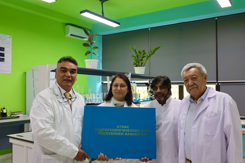
As the country's first comprehensive cartographic study of the underground hydrosphere ensuring water security, the "Atlas of Hydrogeological Maps of the Republic of Kazakhstan" and its creators — Academician of the National Academy of Sciences of the Republic of Kazakhstan Malis Abssametov, Doctor of Geological and Mineralogical Sciences Rakhmatulla Ayazbaev, Academician of the Kazakhstan National Academy of Natural Sciences Yerzhan Kuldeev, Candidate of Geological and Mineralogical Sciences Yermek Murtazin, and Academician of the Academy of Mineral Resources of the Republic of Kazakhstan Vladimir Smolyar, scientists of the Institute of Hydrogeology and Geoecology named after U.M. Akhmedsafin and Satbayev University — were awarded the State Prize of the Republic of Kazakhstan in Science and Technology named after al-Farabi in 2025.