AP23490423 – Comprehensive study of the Ili sedimentary basin in order to identify geological formations of aquifers for underground CO2 storage
Objective of the project – The goal of the project is to identify and evaluate aquifers in Almaty and the Almaty region (Ili sedimentary basin) for technically feasible and economically viable geological storage of CO2 emitted by industrial facilities (plants, factories, thermal power plants, etc.).
Relevance: Almaty and the Almaty Region have the highest CO₂ emissions in Kazakhstan—over 2 million tons per year—due to the high concentration of industrial facilities and thermal power plants. This underscores the need to study geological structures for gas injection and storage. Research work on the project will be conducted at Satbayev University. The university has significant experience in geological and hydrodynamic modeling of oil, gas, and coalbed methane deposits. It also possesses the necessary modern equipment and software.
Scientific supervisor: Doctor of Geological and Mineralogical Sciences, Professor, Istekova Sara Amanzholovna
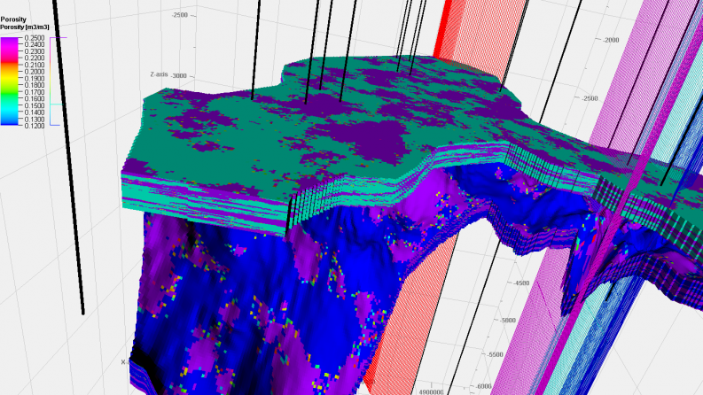
Expected and achieved results: Ten key criteria have been developed for CO₂ storage in aquifers, including the presence of clay traps, reservoirs (preferably sandstones), and sufficient porosity of at least 10–20%. The permeability of the reservoirs should be 100–1,000 mD, and that of the cap rock should be less than 1 mD. The storage depth should exceed 800 m, and the minimum reservoir thickness should be 10–15 m to ensure sufficient capacity. Important factors include CO₂ dissolution in the formation fluid, the availability of reliable geological data, and consideration of the impact of injection on hydrodynamic conditions. During the project, data were collected and systematized across seven disciplines: geology and geophysics, hydrogeology, development, geochemistry, geomechanics, seismology, and drilling. A comprehensive analysis of the region’s geological structure was performed based on materials from the Ili Geophysical Expedition, data from 15 deep wells, and historical cross-sections. A detailed 3D geological model of the East-Ili (Zharkent) Trough was created in the Petrel software suite. The digitization of structural maps has improved the accuracy of spatial analysis. The model comprises over 22 million cells, with sediment depths ranging from 1,235 to 3,700 m. The average reservoir thickness is approximately 15 m, and porosity varies from 12 to 30%. The results obtained form the basis for assessing the storage capacity and prospects for long-term underground CO₂ storage.