AP23489372 – Geotechnical study of rock mass and development of geomechanical monitoring methods for predicting deformation processes in mineral extraction
Objective of the project – Development of a methodology for integrated geomechanical monitoring, which will effectively monitor the geotechnical state of the mountain range and predict deformation processes during the development of the subsoil.
Relevance: The relevance of the project is determined by the need to ensure safe and efficient development of mineral deposits under conditions of increasing pressure on subsurface resources. The geotechnical condition of the rock mass directly affects the safety of workers, equipment, and the stability of production processes. Forecasting deformation processes enables timely prevention of accidents and reduces the risks of emergencies. The study of geomechanical characteristics also contributes to preventing environmental consequences, including landslides and technogenic pollution. The development of monitoring technologies, including GNSS, laser scanning, remote sensing, and automated geodetic systems, provides new opportunities to improve observation accuracy. The integrated use of these methods allows for more accurate modeling of the natural and technogenic state of the rock mass. This, in turn, ensures optimization of mining processes, cost reduction, and increased efficiency of subsoil use. An additional aspect of the project’s relevance is the need to protect structures located within the influence zone of mining operations and to refine the parameters of rock displacement. The project has both socio-economic significances, by reducing material losses and preventing accidents, and scientific and technical importance, contributing to the development of geomechanical monitoring and forecasting methods.
Scientific supervisor: Candidate of technical sciences, Associate Professor, Madimarova Gulmira
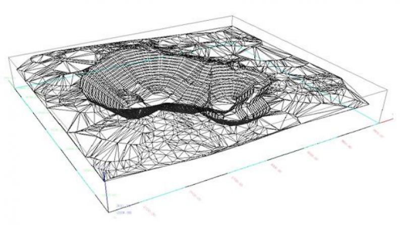
Expected and achieved results: Mine surveying-geodetic and geotechnical data were studied and systematized to assess the stability of rock masses, identify deformation zones, and analyze the stress-strain state. A structural-geomechanical model was developed considering geological structure and mechanical properties of rocks, and a comprehensive database integrating geological, geodetic, and geomechanical information was created. An analysis of natural and technogenic factors affecting deformation processes, including seismic activity and mining operations, was carried out. Mining-geological and geomechanical documentation was examined to determine deposit parameters, rock properties, and engineering solutions. Coordinate and geodetic measurements were analyzed, changes in the rock mass state were identified based on time series, and geological exploration data were integrated. Monitoring objectives were defined, appropriate measurement methods and technologies were selected, reconnaissance was conducted, and a continuous monitoring system based on automated tools was developed. A comprehensive monitoring system was implemented to ensure regular control of surface and subsurface conditions and continuous updating of geological data. A network of observation stations was designed using modern technologies, including GPS, deformation sensors, and automated geodetic instruments. High-precision data on slope structures were obtained using laser scanning and UAVs, and a detailed 3D model of quarry slopes was created. Fracture intensity was assessed, and optimal placement of observation stations was developed for effective monitoring and hazard prevention. Fieldwork included the installation of benchmarks and high-precision measurements, followed by data processing using specialized software. The obtained results improved the accuracy of deformation forecasting and led to obtaining copyright certificate No. 59265 and filing a patent application of the Republic of Kazakhstan No. 413032.
List of publications with links to them
- Нурпеисова Т.Б., Мадимарова Г.С., Абдигалиева С.С., Турегалиева Ж.Т. Применение современных технологий в земельном кадастре // Перспективы применения цифровых технологий в рациональном и безопасном недропользовании: материалы международной научно-технической конференции. – Ташкент: ТашГТУ им. И. Каримова, 2024. – С. 46–49.
- Киргизбаева Д.М., Утесбаев А.К., Мадимарова Г.С. Инновационные технологии создания цифровых карт // Перспективы применения цифровых технологий в рациональном и безопасном недропользовании: материалы международной научно-технической конференции. – Ташкент: Ташкентский государственный технический университет им. И. Каримова, 2024. – С. 43–45.
- Нурпеисова Т.В., Мадимарова Г.С., Ормамбекова А.Е., Жулдикарaева Ф.Т. Моделирование горно-геологических объектов карьера Акжал // Горный журнал Казахстана. – 2024. – № 11.
- Мадимарова Г.С., Нурпеисова Т.Б., Ормамбекова А.Е., Жантуева Ш.А.
Исследование маркшейдерско-геодезических и геотехнических данных бассейна Каратау // Горный журнал Казахстана. – 2025. – № 7 (243). – С. 22–30. - Курманбаев О., Койшыгарин А., Джангулова Г., Мадимарова Г., Сарсембекова З.
- Концепция обработки измерений статическим методом на базовой станции Фабричный // Известия Национальной академии наук Республики Казахстан. Серия геологии и технических наук. – 2025. – Т. 2, № 470. – С. 152–165. – DOI: https://doi.org/10.32014/2025.2518-170X.497